Enjoy your day trip out to magical Spitzkoppe with this private tour.
A perfect getaway to a beautiful destination. Take the scenic road from Walvis Bay to Spitzkoppe for a day out that you will remember forever. The journey to Spitzkoppe is filled with entertainment, as you will stop and see many interesting locations along the way. Continue reading for more details on what to expect.
Spitzkoppe has been an attraction from before written records. The many Bushman paintings found here and in the surrounding area are up to 10,000 years old. On your relaxed drive up to these mountains you will see the Dune Belt, Gravel Plains, Moon Landscape and the Goanikontes Oasis. The rest of the journey has a couple more places of interest, like the Mad Max Fury Road and a hill along the B2 that was used for communication before modern communications.
Lunch is usually a BBQ at Spitzkoppe before you explore the Natural Rock Arch, Matterhorn and Small Bushman paradise. For the more adventurous there is a chain climb up to the Bushman paradise proper. Both Bushman paradise has a local explaining the deeper meanings of the paintings. The way back is along the Small Spitzkoppe where you meet and chat to locals that mine semi-precious stones. Henties Bay is a coastal fishing town with curious houses and the Zeila shipwreck after a long, straight gravel road across the plains.
From Henties Bay the roads improve markedly. Along the road is Wlotzkasbaken before reaching Swakopmund. The last treat of the day is the scenic coastal highway late in the evening. The various locations along the tour route are laid out in much more detail below.
Dune 7 and the Dune Belt
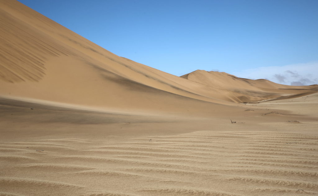
South of the Kuiseb river there is a Dune sea stretching all the way to Luderitz and Sossusvlei. The Kuiseb river changes the landscape dramatically, dividing the landscape into dunes and gravel plains. At the mouth of the Kuiseb river the dunes are generally contained in the banks of the river. North of the C14 highway leaving Walvis Bay, the dunes are stretched out in a thin strip called the “Dune Belt”. This “Dune belt” stretches all the way to the Swakop river, and then there are no more dunes.
Leaving Walvis Bay the landscape changes from beach to desert. On the way to Dune 7 you will have the opportunity to see the “Bird Paradise”. The fresh water lakes at the paradise is formed by the waste water of Walvis Bay being pumped into the desert. The Flamingo love it, and there are a few good photo opportunities of the landscape with contrast between the green reeds and the surrounding dunes. Along the C14 is the railway track as well as the power lines supplying Walvis Bay.
Dune 7 is by far the most popular dune in this belt, with a nice picnic area maintained by Dune 7 Adventures. Dune 7 Adventures makes some pretty good coffee and have tidy toilet facilities. At Dune 7 you can climb the dune to take in the surrounding landscape. Your guide will gladly accompany you, and point out some of the landmarks from the vantage point of the top of the dune.
Leaving Dune 7 you can see a few untouched dunes for some real “Lawrence of Arabia” type of photos along the dune belt. This belt has served as location for a few movies like 10,000 BC and Flight of the Phoenix, among many others. For the most part you can watch the dunes go by as the landscape unfolds on the very nice tarred road to the Swakop river. At the Swakop river the dune belt is left behind, and the landscape changes to gravel plains.
Moon Landscape in the gravel plains
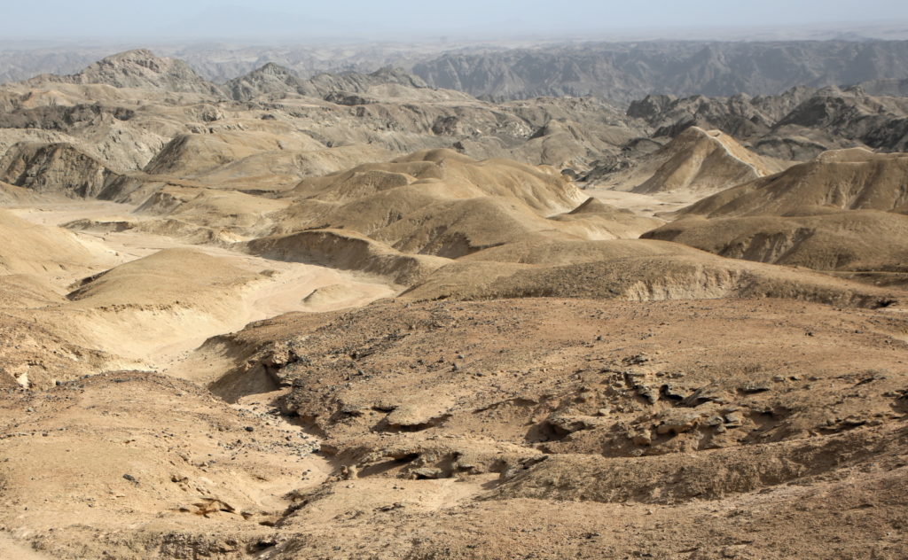
In the 1960’s the Welwitchia trail that was laid out in an effort to boost environmental awareness of this hyper-arid landscape. You will stop at some of the locations marked on this trail, too. The lichen and other flora that grow in this region is especially well adapted for this hyper-arid climate. Apart from the occasional bug, there is no wildlife in this area. Cutting through this landscape is the Swakop river, and it carved a magnificent canyon in the sedimentary rocks.
From the lookout points on the edge of the canyon looking in, the landscape already looks a bit like the surface of the moon with it’s complete desolation and bare peaks. The best part of this tour is that we slowly drive into this landscape to take it all in! Compared to the badlands in Arizona, the form and color of this canyon is breathtaking. Photographers from around the world has asked why landscape is not advertised more, it’s that great.
Goanikontes Oasis

Goanikontes is an oasis in the Swakop river from before Europeans arrived. Officially established in 1848, it was used to grow food for the population of Swakopmund and the German troops. Recently under new management, the facilities at Goanikontes are world-class. The historic farm building houses a small curio shop, and snakes and scorpions in aquariums. They provide free wifi in the restaurant area.
The open air restaurant with it’s amazing atmosphere is where you have lunch. The menu is pretty diverse with something for everyone. Liquid refreshments here include good coffee and beer “As cold as your mother-in-law’s heart”, as stated on one of the signs next to the road. There are massive trees providing shade and for the tables, and perch for the many small bird species that live in the Swakop river. The oasis also has an eclectic collection of farm animals, some roaming freely. The caged ones you can see for free, if you ever wanted to see a Alpaca, pig or goat up close.
There are a few other attractions at this location that include classic cars and an artificial lake. On a side note, this place has good accommodation and activities if you are planning a holiday stay over at the coast.
Mad Max Fury Road
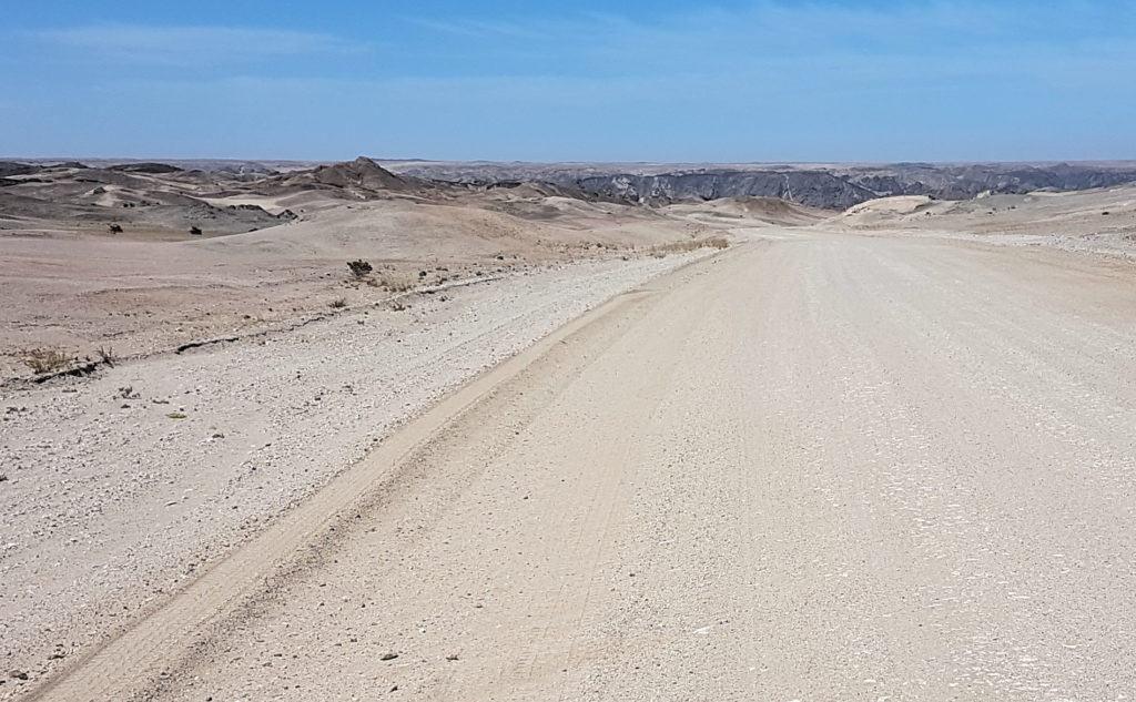
Leaving the Oasis along the D1991 on the way to Spitzkoppe, also leaves behind the Moon Landscape. The first few kilometers of this road was used in Mad Max 4 – Fury Road. The road itself is in excellent condition, the scenery around is even more so.
As with the rest of the Moon Landscape, there is a lot of variation in terms of form and color in the rocks. This area is used for films quite often, and it’s not hard to see why. Once out of the Swakop River Canyon the rocks give way to rolling hills and then flat open plains, with the Rossing Mountain ahead. Close to the Rossing Mountain is where the D1991 joins the B2 tarred road which leads to close to Spitzkoppe.
Heliograph Hill
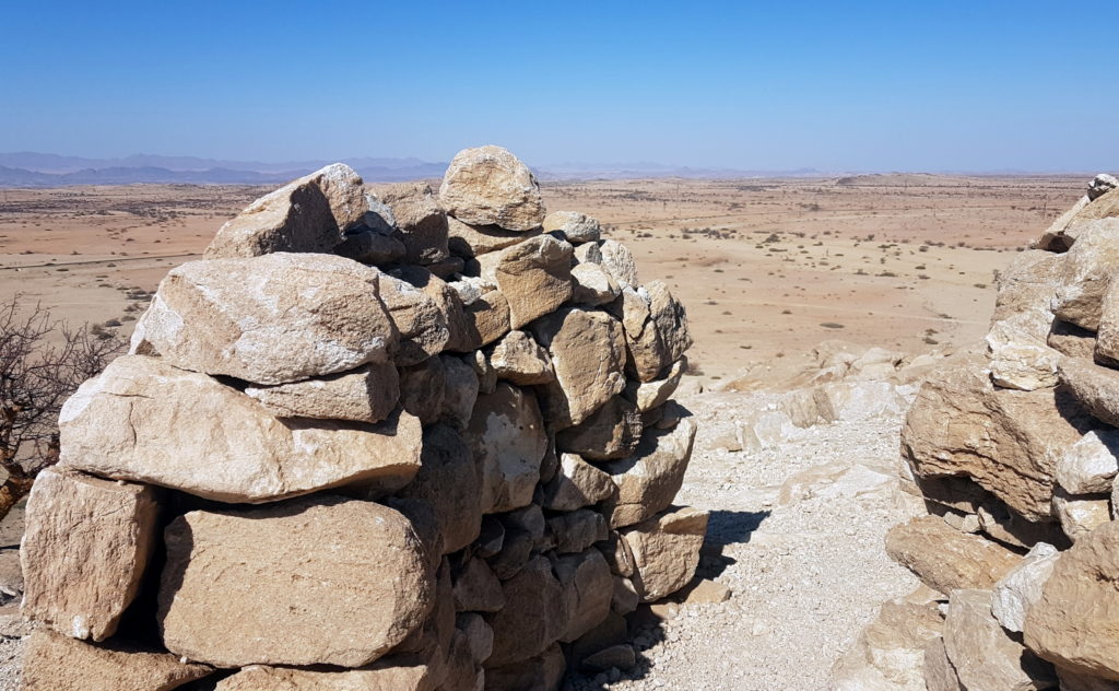
Situated along the B2 on the way to Spitzkoppe is an unassuming hill with an interesting history. With the natural vantage point over the Khan river canyon and the flat landscape around, this little hill was of some importance to the German troops late in the 1800’s. On top of the hill there is a small stronghold made of rock where soldiers used to be stationed. You can still see where the rooms were, as well as the lookout. Well defended from any angle, and extremely well thought out, this stronghold had another important purpose.
Since the telephone has just been invented half a world away, and the distances were great in Namibia, communications between Swakopmund and Windhoek were slow, as messages had to be brought by horseback. However, with plenty of sunshine and troops stationed all over the country on high hills, heliographs were used to speed that message passing up to a couple of hours. This hill is a fine example of that network.
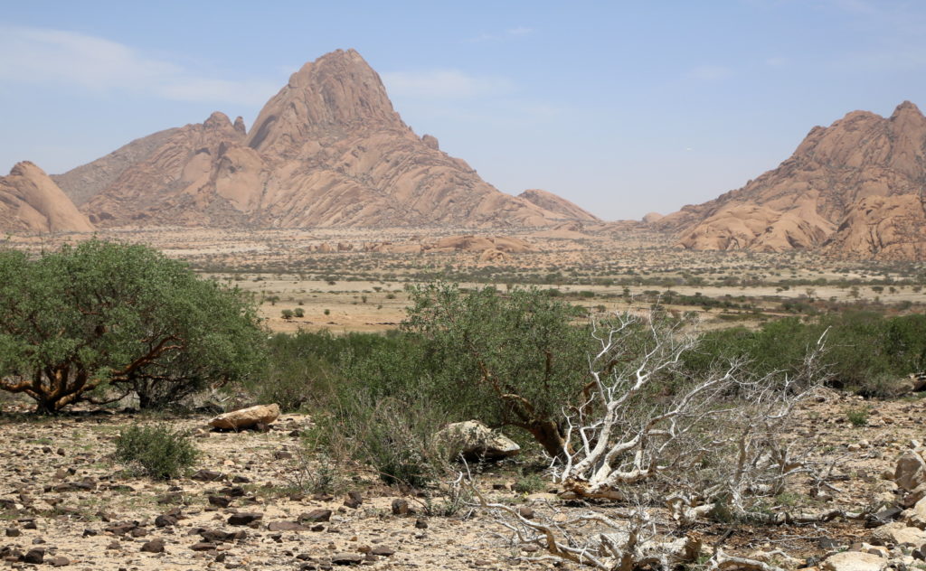
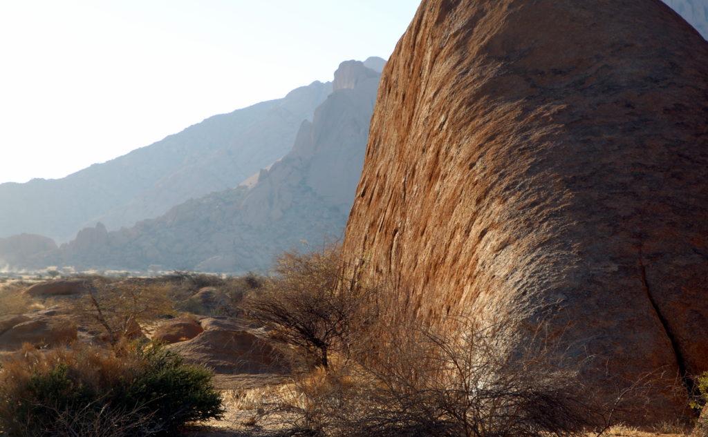
Spitzkoppe Mountain
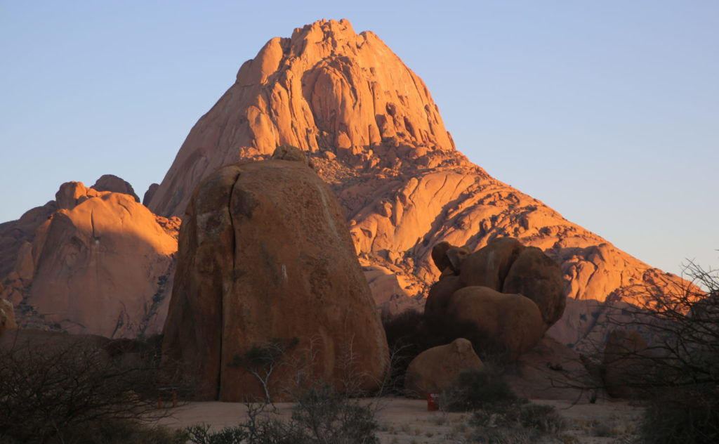
Spitzkoppe is one of Namibia’s star attractions, and once you have visited it, you would definitely agree. Rising majestically above the surrounding landscape, Spitzkoppe is a fine example of an inselberg. The mountain range consists of Spitzkoppe proper and Little Spitzkoppe a small distance to the West. Camp sites have been laid out and provides stunning views of the stars for overnight campers. Administration of the campsites and mountain range is handled by the Spitzkoppe community.
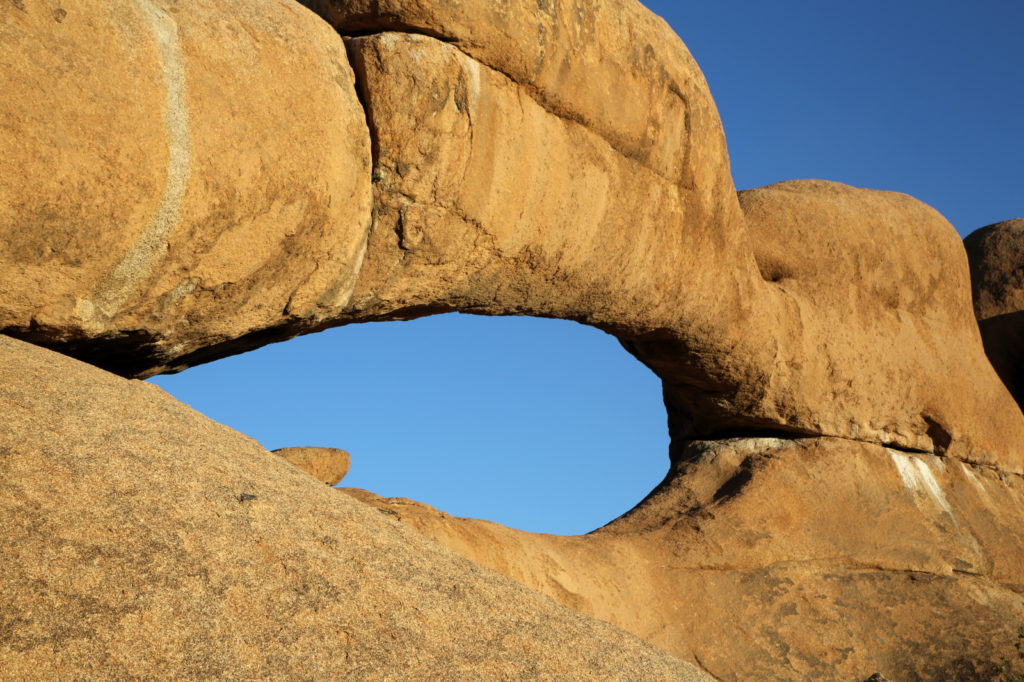
You will be exploring the various interesting geological features of this mountain range like the Rock Arch, the Matterhorn and the Rock Pool. With a bit of luck you might see some wildlife as well, like the dassie. Lunch will be prepared in a spot with some shade against the midday sun, and usually consists of a BBQ. What’s on the menu is up to you, BBQ & beers to finger food & sparkling water, and anything in between. You will also be shown the other attractions of Spitzkoppe, like the community village that formed close by, as well as the rock paintings described below.
Bushmen (San) Rock paintings
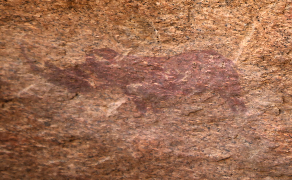
There are a lot of Bushmen (San) paintings at Spitzkoppe and Little Spitzkoppe. You will see the Little Bushmen Paradise, and the proper Bushmen’s paradise. Both of these have a live guide giving you the information and interesting facts about this unique art form, it’s age and the people who made it. You will just have to see & hear the guide for yourself to believe all the information captured in these pre-historic pictographs.
All this art is protected as it’s pretty old, and the know-how of making the paint has been lost. Unfortunately this has not stopped unscrupulous people from damaging the art in many ways, from chipping away at the granite behind in a misguided attempt to remove the art to simply wetting it down to boost the contrast, whereby washing the paint away, like in the example above.
Henties Bay and Zeila Shipwreck
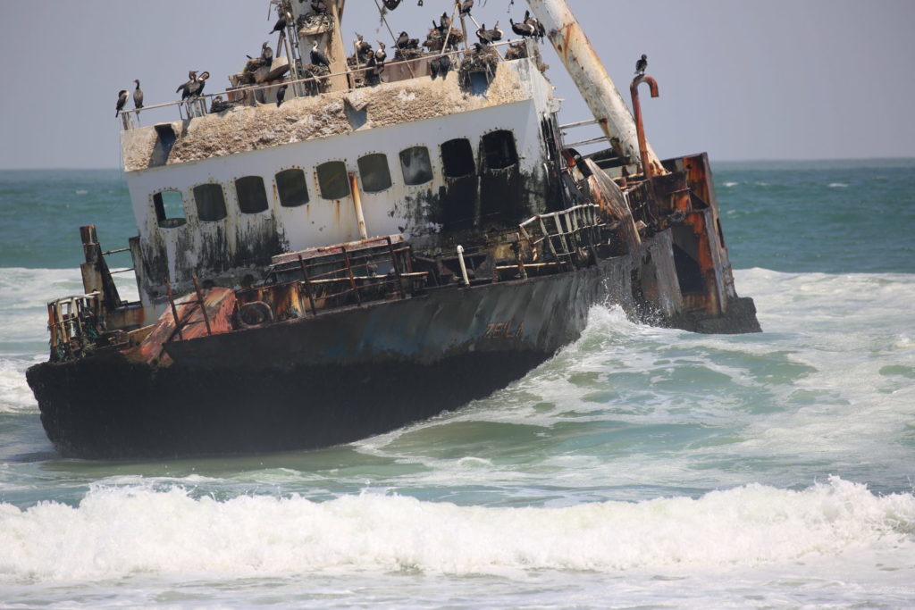
On our way back from the Spitzkoppe we pass through the town of Henties Bay. It’s a sleepy little fishing town, with beautiful houses, each with an interesting name. You will be taken on a little route through the town to appreciate it a little more. Past Henties Bay, is the Zeila shipwreck, just off the main road.
The Zeila broke free from her tow and ended up on the beach. Now it provides shelter for fish and has become a favorite fishing spot for the locals. You will have ample opportunity to photograph the Zeila frin various angles. The road from Henties bay to Swakopmund is a newly paved tar road, passing the little settlement of Wlotzkasbaken.
Swakopmund
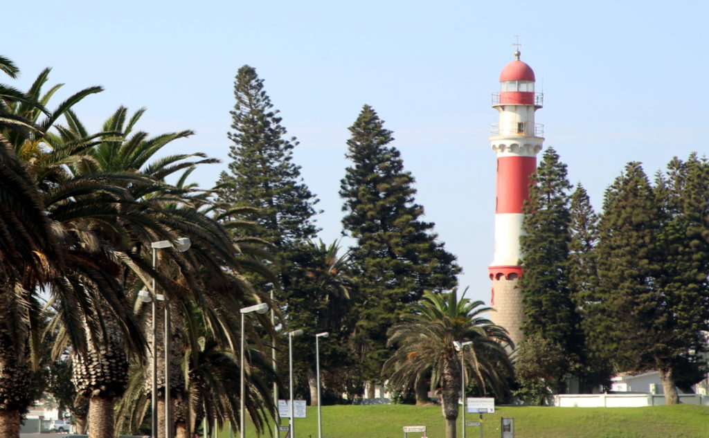
No visit to the coast would be complete without a visit to Swakopmund. Driving by the historic buildings and landmarks of this distinctly German town offers you the opportunity to learn about how life was back in the late 1800’s when this area was settled. You will be shown a few landmarks around Swakopmund, which include the Lighthouse, Jetty and Mole. There is more than enough time to soak up a little of the atmosphere of this touristy town before heading back to Walvis Bay.
Coastal Highway
The last 30 km of the B2 highway that connects Walvis Bay with Johannesburg in South Africa runs in between the ocean and the dune belt. This stretch of road has a couple of really beautiful spots. As it will be nearing sunset the light for photos will be great. Near Swakopmund there is usually a bit of paragliding going on, and nearer to Swakopmund the bird island is quite an interesting feature from the 1930’s. Along the road you also have Longbeach and Dolphin beach settlements.
Details
- Duration: 9 hours
- Activity level: Moderate to relaxed
Inclusions
- Cool bottled mineral water, still and sparkling
- Free pickup in Walvis Bay or Swakopmund
- Private, air conditioned transport
- Local guide
Optional Extras
- Pickup at your ship inside the port of Walvis Bay
- Special or alcoholic drinks for the tour
- Food for the tour, there are many options for lunch!
Pickup Services
You will only get the best service at Awesome Chapters:
- Free in Walvis Bay or Swakopmund:
- Your adventure starts at your accommodation because your private tour guide will pick you up with the tour vehicle.
- Time:
- Contact us for free help in picking the best time. As this is an all day long tour, earlier is better.
- Your pickup is fixed during the booking process.
- Cruise liners:
- If you are arriving on a cruise liner, you have the option of being collected at your the ship, inside the harbor gates.
Booking – Email
If you are interested in this tour, but you would like to have a discussion with us first, you are welcome to contact us for some human interaction. The booking will be made for you with the information from our chat. We love hearing from you, so even if you do not want to book the tour, and just want some more information, you are still welcome to drop us an email.
Alternatively, drop us a line on the contact form below and we will come back to you!